Ice Man wrote:Fightin' Irish wrote:NMB[shorty]1975 wrote:Is there any satilite photos sites that show any of the turbine sites. I have checked Google Earth but imagery seems to be too old.
I am not taking sides on the issue. I no longer live in Tyrone or the surrounding area so my opinion doesn't apply.
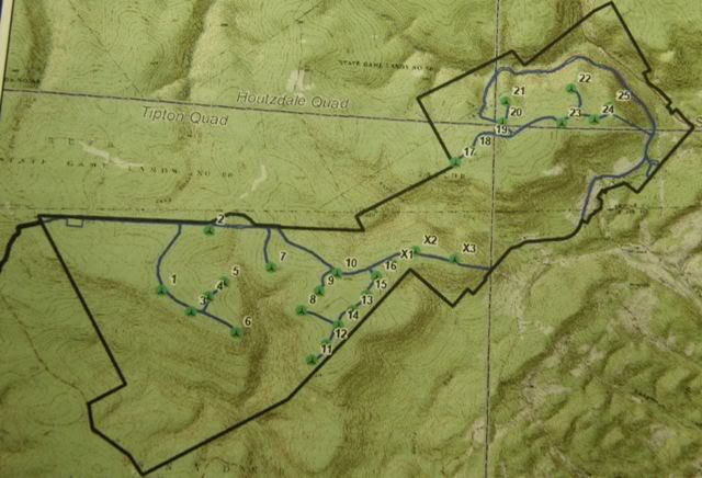
Turbine locations are green circles, numbered. Roads are blue. Solid black line is project boundary.
Watershed Management Program Manager, 208 West Third Street, Williamsport, PA 17701.
Centre County Conservation District: 414 Holmes Avenue, Suite 4, Bellefonte, PA 16823, (814) 355-6817.
NPDES permit # PAI041409007
Sandy Ridge Wind, LLC
1801 Market Street
Suite 2200
Philadelphia, PA 19107
Affected waterways:
Three Springs and Sand Spring Runs HQ
Sink and Decker Runs TSF
Vanscoyoc Run CWF
Big Fill Run EV
ON THE MAP ABOVE, TURBINES 1-6 ARE PROHIBITED BY THE FAA AS A HAZARD TO AIRCRAFT
Hi folks,
I copied the sections from the FAA letters to Gamesa for the denied turbines, in case you would like to see what the FAA sent to Gamesa. Each turbine app generates an individual letter from FAA. I copied parts of each letter pertaining to the ones that were denied by the FAA.
Laura
Tyrone App to the FAA
The following are hazardous at any height to aircraft:
SR-S1
SR-S2
SR-S3
SR-S4
SR-S5
SR-S6
Excerpts from the FAA letters:
** NOTICE OF PRESUMED HAZARD **
The Federal Aviation Administration has conducted an aeronautical study under the provisions of 49 U.S.C.,
Section 44718 and if applicable Title 14 of the Code of Federal Regulations, part 77, concerning:
Structure: Wind Turbine SR - S3
Location: Tyrone, PA
Latitude: 40-43-22.27N NAD 83
Longitude: 78-18-00.82W
Heights: 475 feet above ground level (AGL)
2959 feet above mean sea level (AMSL)
Initial findings of this study indicate that the structure as described exceeds obstruction standards and/or would
have an adverse physical or electromagnetic interference effect upon navigable airspace or air navigation
facilities. Pending resolution of the issues described below, the structure is presumed to be a hazard to air
navigation.
If the structure were reduced in height so as not to exceed 0 feet above ground level (2484 feet above mean sea
level), it would not exceed obstruction standards and a favorable determination could subsequently be issued.
** NOTICE OF PRESUMED HAZARD **
The Federal Aviation Administration has conducted an aeronautical study under the provisions of 49 U.S.C.,
Section 44718 and if applicable Title 14 of the Code of Federal Regulations, part 77, concerning:
Structure: Wind Turbine SR - S4
Location: Tyrone, PA
Latitude: 40-43-29.69N NAD 83
Longitude: 78-17-51.19W
Heights: 475 feet above ground level (AGL)
2955 feet above mean sea level (AMSL)
Initial findings of this study indicate that the structure as described exceeds obstruction standards and/or would
have an adverse physical or electromagnetic interference effect upon navigable airspace or air navigation
facilities. Pending resolution of the issues described below, the structure is presumed to be a hazard to air
navigation.
If the structure were reduced in height so as not to exceed 0 feet above ground level (2480 feet above mean sea
level), it would not exceed obstruction standards and a favorable determination could subsequently be issued.
Issued Date: 07/30/2009
Josh Framel
Gamesa Energy USA L.L.C.
One South Broad St. 20th Fl
Philadelphia, PA 19107
** NOTICE OF PRESUMED HAZARD **
The Federal Aviation Administration has conducted an aeronautical study under the provisions of 49 U.S.C.,
Section 44718 and if applicable Title 14 of the Code of Federal Regulations, part 77, concerning:
Structure: Wind Turbine SR - S6
Location: Tyrone, PA
Latitude: 40-43-13.89N NAD 83
Longitude: 78-17-33.07W
Heights: 475 feet above ground level (AGL)
2930 feet above mean sea level (AMSL)
Initial findings of this study indicate that the structure as described exceeds obstruction standards and/or would
have an adverse physical or electromagnetic interference effect upon navigable airspace or air navigation
facilities. Pending resolution of the issues described below, the structure is presumed to be a hazard to air
navigation.
If the structure were reduced in height so as not to exceed 0 feet above ground level (2455 feet above mean sea
level), it would not exceed obstruction standards and a favorable determination could subsequently be issued.
Issued Date: 07/30/2009
Josh Framel
Gamesa Energy USA L.L.C.
One South Broad St. 20th Fl
Philadelphia, PA 19107
** NOTICE OF PRESUMED HAZARD **
The Federal Aviation Administration has conducted an aeronautical study under the provisions of 49 U.S.C.,
Section 44718 and if applicable Title 14 of the Code of Federal Regulations, part 77, concerning:
Structure: Wind Turbine SR - S1
Location: Tyrone, PA
Latitude: 40-43-31.22N NAD 83
Longitude: 78-18-18.91W
Heights: 475 feet above ground level (AGL)
2988 feet above mean sea level (AMSL)
Initial findings of this study indicate that the structure as described exceeds obstruction standards and/or would
have an adverse physical or electromagnetic interference effect upon navigable airspace or air navigation
facilities. Pending resolution of the issues described below, the structure is presumed to be a hazard to air
navigation.
If the structure were reduced in height so as not to exceed 0 feet above ground level (2513 feet above mean sea
level), it would not exceed obstruction standards and a favorable determination could subsequently be issued.
** NOTICE OF PRESUMED HAZARD **
The Federal Aviation Administration has conducted an aeronautical study under the provisions of 49 U.S.C.,
Section 44718 and if applicable Title 14 of the Code of Federal Regulations, part 77, concerning:
Structure: Wind Turbine SR - S2
Location: Tyrone, PA
Latitude: 40-44-00.61N NAD 83
Longitude: 78-17-53.39W
Heights: 475 feet above ground level (AGL)
2982 feet above mean sea level (AMSL)
Initial findings of this study indicate that the structure as described exceeds obstruction standards and/or would
have an adverse physical or electromagnetic interference effect upon navigable airspace or air navigation
facilities. Pending resolution of the issues described below, the structure is presumed to be a hazard to air
navigation.
If the structure were reduced in height so as not to exceed 0 feet above ground level (2507 feet above mean sea
level), it would not exceed obstruction standards and a favorable determination could subsequently be issued.
** NOTICE OF PRESUMED HAZARD **
The Federal Aviation Administration has conducted an aeronautical study under the provisions of 49 U.S.C.,
Section 44718 and if applicable Title 14 of the Code of Federal Regulations, part 77, concerning:
Structure: Wind Turbine SR - S5
Location: Tyrone, PA
Latitude: 40-43-36.94N NAD 83
Longitude: 78-17-42.20W
Heights: 475 feet above ground level (AGL)
2917 feet above mean sea level (AMSL)
Initial findings of this study indicate that the structure as described exceeds obstruction standards and/or would
have an adverse physical or electromagnetic interference effect upon navigable airspace or air navigation
facilities. Pending resolution of the issues described below, the structure is presumed to be a hazard to air
navigation.
If the structure were reduced in height so as not to exceed 0 feet above ground level (2442 feet above mean sea
level), it would not exceed obstruction standards and a favorable determination could subsequently be issued